Project - virtual Saratov
Saratov is the city where I was born and raised. My grandfather loved to talk about the city, showing interesting buildings, what used to be in them, and how the city evolved. Not surprising, since he worked at Saratov’s Capital Construction Department. Thanks to him, I even know where Stolypin lived before he built his main mansion :). Or that the bridge between Saratov and Engels was supposed to be 4-lane but was made 3-lane just to meet the deadline :). My grandfather also had a scrapbook of articles on the city’s architecture, which he constantly cut out from newspapers, resulting in a large collection of historical information. It’s not archival documentation, but a valuable set of references to important sources.
Saratov was quite a significant city in the early 20th century — it was among the top in population after Moscow and St. Petersburg, and was a desirable place to move to.
I’ve always wanted to see what this city looked like. But unfortunately, many buildings are gone, so it’s impossible to experience it in person like in St. Petersburg.
Many interesting buildings and churches were demolished. Just the stretch from Lipki Park to Gorky Street is telling (Then → Now):
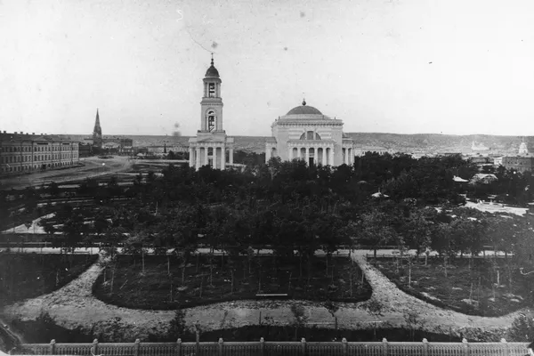 Then: Church in the city center
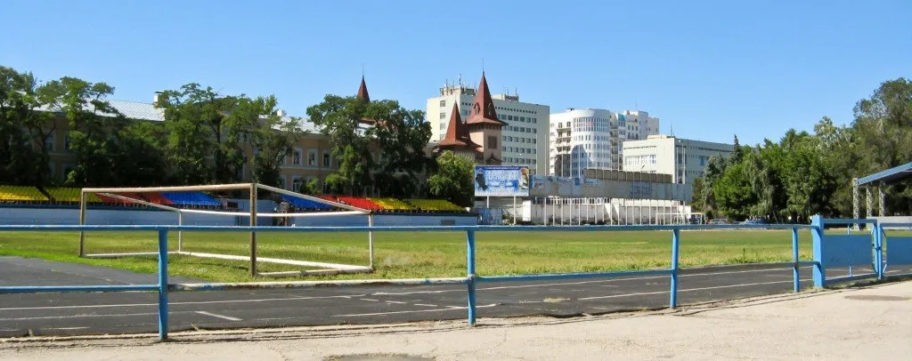 Now: Dynamo Stadium in its place
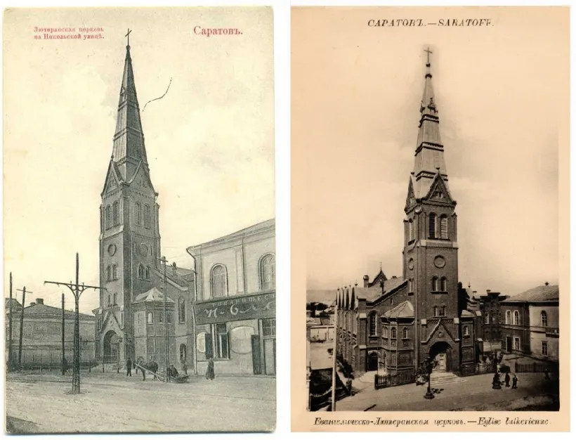 Then: Lutheran Church
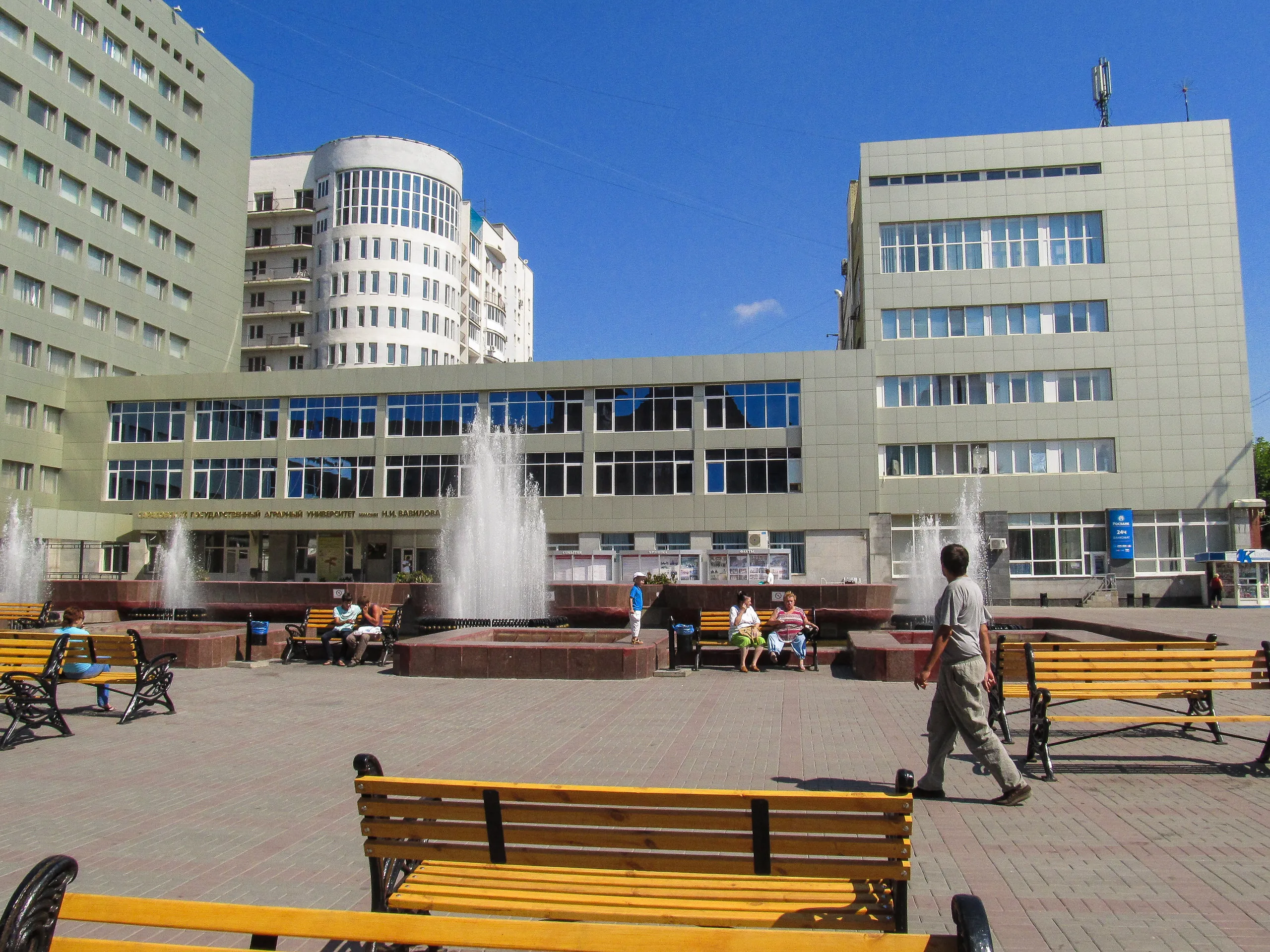 Now: Agricultural Academy building near the fountain
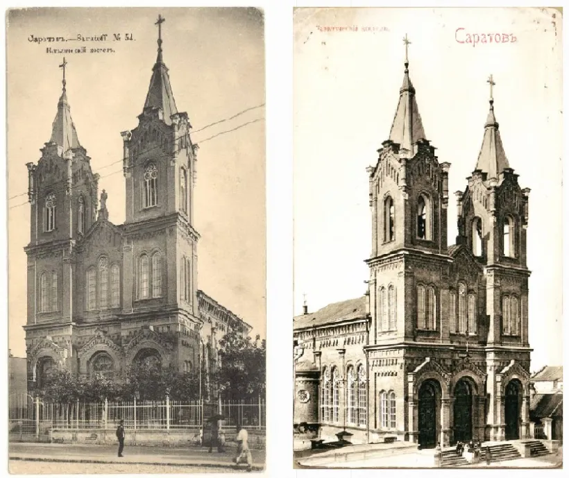 Then: Catholic Church
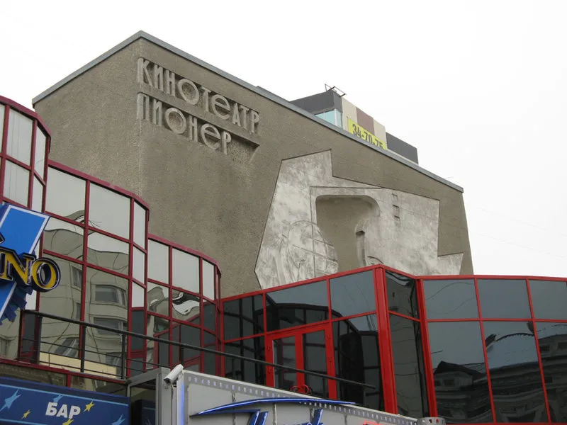 Now: Pioneer Cinema (the building remained, but the bell towers were destroyed, the facade simplified, turned into a cinema, and now further covered in glass)
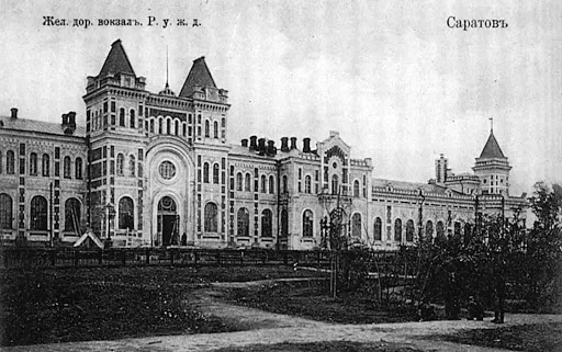 Then: Old Railway Station
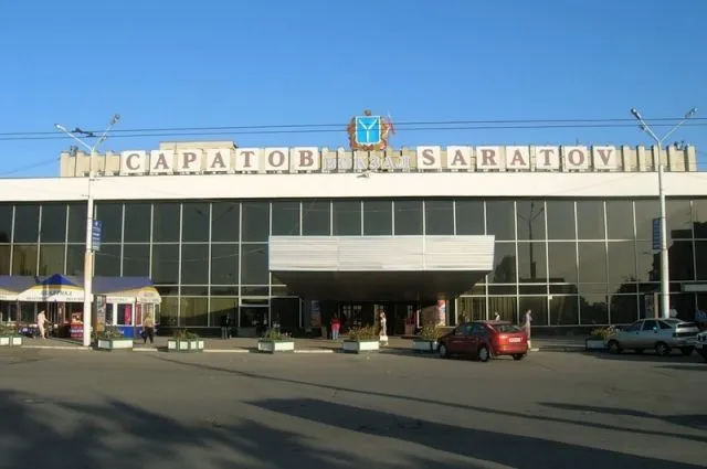 Now: New Railway Station
There are actually many such vanished buildings, the city looked completely different. And I still wonder what motivated such drastic changes to such beautiful buildings and the city’s appearance.
Moreover, there are very few places where you can still feel the old city today — most streets are mixed with Soviet-era or modern buildings. There’s no clear division between the old and new city.
That’s why I had the idea to make a virtual model of the city, one you could walk through in VR, or view via desktop/browser, or see overlaid in AR on your phone.
With modern technologies, this is more than feasible.
Technical Architecture of the Project
This is a very early architecture, and it may change over time.
The project is divided into several parts:
1. Content Creation
First, of course, the buildings themselves. What do they look like? We can only partially infer from old photos. To recreate a 3D model, we need architectural plans.
I’ve found that while there are a few detailed maps from the late 19th–early 20th century showing building footprints, it’s quite hard to obtain the actual plans — unfortunately, I don’t know if drawings of old house plans exist to base models on. One hypothesis is to start with the Committee on Architecture and the Archive.
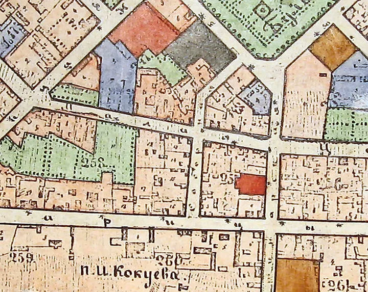 Sample 1881 map
Let me clarify: the goal is not to recreate the city with perfect accuracy — that’s impossible. All photos and plans come from different years, and there’s no unified snapshot for a specific date; many gaps exist due to lack of photos. For example, the plan above is from 1881, but 20 years later, the area may have changed completely.
Even if they had survived — how many houses were in the city? 1000? How long would it take to create 3D models of 1000 houses? Even one per day would take years.
So it seems necessary to generate these houses, based on a few key types and their components. In other words, build a dictionary of elements that buildings of each type might be composed of. For instance, in the area beyond the Glebuchy ravine, there are mainly wooden houses without stables, possibly sharing similar window frames, log stacking methods, doors, and number of floors.
With several standard components per house type, we can construct as many buildings as needed, like Lego — of various sizes, number of floors, and other features.
But any generation relies on understanding what to generate, so historically accurate data is crucial.
I see this task in two parts — creating landmarks and creating typical houses. Landmarks are manually modeled, while generic houses should be generated.
It’s more efficient and correct to pre-generate houses so that client devices (phones, computers) don’t need to use resources on this. Also, generation quality can be improved over time. The output should be building data that can be easily read by any device.
Some options:
glTF — widely supported, has good compression, can be stored in PostGIS with placement coordinates
CityJSON — a GIS data format supported by many tools. If our data becomes accurate enough, it can be reused in other historical reconstruction projects. It’s also used in GIS preservation tools — https://www.3dcitydb.org/3dcitydb/ Currently, this seems the more promising option.
The choice of format will depend on how we plan to store and serve the data.
I know of a project “Moscow Through an Engineer’s Eyes” — “Moscow That Never Was” where they present unrealized architectural projects via VR. The idea is similar.
2. Creating a historically accurate city layout based on topography
The topography might not have changed much, although the embankment reconstruction in the 60s, the bridge construction, and the Volgograd hydroelectric station affected one major part — the riverside. The dam raised the water level, and the Volga used to be much narrower. New islands appeared during bridge construction, and the embankment was paved in asphalt and granite. So, the city plan and topo data are very important. I’ve found a 1905 map so far, but it’s not that precise. Still searching.
3. Storage and delivery of content data
All generated content is stored on a server in a POSTGIS-based DB, for convenient tile-based data delivery, enabling smooth tile-by-tile loading instead of everything at once. We can build our own solution or try CityDB.
4. Content Display
- Smartphone, XR
- VR headset
- 3D desktop/browser app
It’s not yet clear which of these will be most in demand. Our system must support all of them — one of the interesting architectural challenges.
Roadmap
- Submit grant application for local history/museum activities. There are many, e.g. Sergey Potanin’s Museum 4.0. For this, we need an NGO or museum — currently choosing or planning to found one.
- Prepare technical architecture
- Produce content (building generation, city landmarks, roads, riverbeds, lot boundaries, etc.)
- Implement content viewing system (iOS, Android apps, Oculus Quest apps, desktop and web apps)
- Release the project for use. Publish historical data for open use (so others can use it too)
- Upon receiving new historical data — update by replacing generated content with accurate historical models
- Estimated duration — 1.5 years from the grant start, but we’ll know more after preparing the application and discussions with key project members.
What We Need
People. With a passionate team, we can make this happen. We need people interested in any of the involved fields. This project provides insights into urban planning, generative design, game development, VR, and app architecture.
Currently, I think it would be great to have:
- Architects (civil engineering) — to create building content. Ideally, with background knowledge of architecture and urbanism in the Volga region from the 18th–early 20th century
- Historians and local history experts — to ensure buildings match historical reality and avoid generating French villages in Glebuchy ravine
- ML specialists — we may need to generate some data using neural networks
- Developers — depends on architecture, but likely:
- Python developers (current idea: generate buildings via Blender API)
- Unreal Engine / C++ for the viewing app
- Web developers — for the browser-based viewer
- Everyone interested in the history of Saratov or similar cities
I’ll keep posting updates as the project progresses
——Translated with ChatGPT from original version—–